Friday, October 15, 2010

Colorado National Monument

Independence Monument


This is our last real day of sightseeing. We’re off to Grand Junction to visit Colorado National Monument. We take Utah 128 through the Colorado Canyon always a scenic drive. After setting up camp, we head for the monument. After 3 weeks of sandstone, it is sort of anticlimactic, but surprise! We actually have new layers of sandstone, the Morrison layer filled with dinosaur bones and the Dakota formation. These are on top of our usual Entrata and Navajo sandstone. We took a nature trail, but there were no booklets left. Of course, at this point, we guess what the signs are pointing to – we know most of the desert plants and rock layers. We even know most of the animals including those that live in potholes.
There are some beautiful views: Independence monument and Ute Canyon with its fall colors are particularly beautiful.
Ute Canyon

So how do you sum up this vacation? While I’ve labeled it the Utah vacation or more accurate summary would be the Colorado plateau vacation: western Colorado, Northern Arizona, and Southern Utah. We’ve seen a lot of red sandstone everywhere, encountering the same layers over and over, but in different formations. The highlights were Monument Valley, Antelope Canyon, Zion Park (big horn sheep and the hummingbird talk), and our drive down Shaffer Trail in Canyon land. We were shocked at how many Europeans we saw everywhere, especially once you were hiking. I was expecting to see them in the major National Parks, but we met many every day. Most were young couples from Germany, Holland, and England who we ended up talking to as well as lots of other languages that we didn’t know.

Thursday, October 14, 2010

Arches National Park - Delicate Arch

Double Arch

We saw lots of arches today. We visited the Windows portion of the Park to hike to North and South Window as well as Turret Arch. Then it was a short walk to one of my favorite arches, Double Arch. This was a former pothole that eventually lost it’s center forming two adjacent arches. In the afternoon, I took the short, but strenuous hike to delicate arch. I couldn’t believe the number of people who were doing this hike. A good portion of the trail goes over slick rock, and even here you could tell where the trail was because of the darkened portion in the stone. The hike was well worth it, I couldn’t believe how incredible delicate arch is. It was much larger than I expected and so isolated from any other rock formations, you wonder how it came to form here. Simply incredible! We tried to take one of the 4 wheel drive roads out of the park, but it proved too much for us! It climbed straight up a hill with deep ruts and we decided not to chance getting stuck.

Delicate Arch

Wednesday, October 13, 2010

Arches National Park - Landscape Arch

Landscape Arch


Time for Arches National Park, last time we were here it was 104 degrees, today the high will be in the mid-70s. We had hoped to camp there, but I didn’t make a reservation in time and the campground we were in also was going to fill that day since it’s the start of a 4 day weekend for school. So we moved to the Moab KOA in the morning before heading to the park. I took a one-way hike down Park Avenue which has these huge towers rising above the wash. At the end of the wash was another huge rock called Courthouse Towers. Mary picked me up at the end and we continued down to Balanced Rock. There were at least 3 other balanced rocks in the vicinity so we wondered why they picked this one?
In the afternoon, we went to the Devil’s Garden area of the park and took the hike to Landscape Arch, taking short side trips to Tunnel Arch and Pine Tree Arch. This is the longest arch in the park, and its shape is so interesting. They no longer let you hike underneath the arch, since quite a bit of rock fell off several years ago.

Tuesday, October 12, 2010

Island in the Sky portion of Canyonlands

Green River from Deadhorse Point
Our day started at Dead Horse Point State Park, which overlooks the canyons of the Green and the Colorado rivers. The point got its name since it narrows to 30 feet at one point, which allows the cowboys to corral the horses on that point. The legend has it that after selecting the best horses, one group left the rest to die of thirst on this point.
Then we went on to the Island in the Sky portion of Canyonlands National Park. This part of the park is 2000 feet over the two rivers. We went from viewpoint to viewpoint and each would get better. We took a hike to upheaval overlook. This part of the park looks different (colors are grays and browns) in soft hills then the rest. There are two key theories to what happened here: either a salt dome collapsed or a meteor landed here spraying this material around. The other interesting hike was to Mesa Arch, which has a beautiful view of Buck Canyon (the Colorado river canyon) behind the arch.

Shaffer Trail (1500 feet down)


We ended the day with a 4 wheel drive adventure, we descended the island on the Shaffer trail. Mary almost had a heart attack as we went down this very steep, mostly one lane, shelf road with a drop off of 1500 feet on one side. We descended along a good portion of this at less than 5 mph and were lucky that the 3 cars we passed were along portions where we had already pulled off for the view. Even when we reached the end of the cliffs, it remained and interesting road going through many washes and cliff edges as we passed by dry streams that led to the Colorado. We had seen this road from many of the viewpoints in both parks, and now we were on it. Well, it took us 2 ½ hours of driving to finally reach paved roads, but it was definitely a worthwhile trip that few take. We had dinner at Moab Brewery, the food was good and they had both a good amber and stout beer.


Colorado River along our drive

Monday, October 11, 2010

Needles section of Canyonlands

Newspaper Rock
We’re off to the south end of Canyonlands National Park, called the needles. We stopped on the way to see Newspaper Rock, a series of petroglyphs and pictogryphs. There were about 6 of us there and we never felt that we found them. On returning later that afternoon, we found that we had hiked off on the wrong side of the parking lot. There were many pictures obvious on the right side. These pictures were created from 3 different cultures. Most of the human like shapes look like big men with antlers, and there are lots of big horn sheep.
Needles section as seen from Grand View Point
The needles section was fairly quick to explore by car. It’s obvious, why it is called needles as there are many spires that apparently go for miles (you can only see the first row of needles from the roads). There actually isn’t too much to see from the car, other than canyons (duh!) and rock formations. It was more interesting to hike on the pothole trail to get a closer look and the roadside ruin trail to get up close to an ancient granary.

Sunday, October 10, 2010

Goblin Valley State Park

Goblin Valley


We left Capital Reef and continued down Utah 24 which is another scenic byway. Our primary stop for the day was Goblin Valley State Park. It had been my intention to camp here, but we soon discovered you can explore the entire park in about 2 hours. The goblins or mushroom shaped stone figures are made of Entrada sandstone. Fracture patterns within the bed create zones of weakness, and the erosion begins. The edges and corners of these fractures weather more quickly producing spherical-shaped goblins.
The narrows of Little Wild Horse Canyon

Just down the road is another slot canyon, Little Wild Horse Canyon. The hike is primarily in a wash so it was fairly easy, until we came to a dry fall. Here we had to skirt the side of the wash and the climbing got a little too much for Mary. She decided to wait it out, while I explored the canyon. While not as spectacular as Antelope Canyon, this one gets very narrow. For several hundred feet, you hoped you didn’t meet anyone going the other way, because there was nowhere to pass. It was a fun canyon to hike. If you want to make it a round trip, you can also hike down Bell Canyon.
Given that it was only 2:30 PM, we decided to head into Moab for camping that night.

Saturday, October 9, 2010

Grand Staircase Escalante

Grand Staircase Escalante


Today, we’re headed down Utah 12, a scenic byway from Bryce Canyon to Capital Reef National Park. Our first stop was Kodachrome State Park. I was expecting much more colors than the mostly reds and whites we saw. The highlights of the park are the sandstone spires that dot the park. We took a short loop hike to see a little of the scenery. Some of the hike was in a wash, which were pretty muddy after all the rain this last week. Leaving the park, we headed down toward Grand Stair Case-Escalante National Monument. Highway 12 is one of only 2 roads that cover some of the corners of the monument. This part of Utah was the last part of the continental US to be explored, by John Wesley Powell in the early 1870s. The most spectacular part was the road from Escalante to Boulder, Utah. This section is called the million dollar highway, it was completed in the late 1930s. Boulder was the last town in the U.S. to get their mail by mule train – a 3 day trek from Escalante before this road was put in. The road north from Boulder to Torrey, Utah wasn’t paved until 1965. So this portion was only open 6 months a year. The scenery fit the remoteness of this area. Lots of impassable rock formations. It took most of the day for us to cover this 150 miles, but we made many stops on the numerous viewpoints.

Climb up Boulder Mountain to Torrey

Friday, October 8, 2010

Capital Reef

Mary at Hickman Bridge


We had hoped to take some of the dirt roads in the park today, but because of that recent rain, they are just mud. The rangers told us, that they should be dry in another 3 days and then they’ll try to push aside the mud. Oh, and the paved road just opened yesterday at 2:30 PM. So we visited the school house and one of the last settler’s cabins in Fruita. We just missed the last of the orchard fruit, apples were being picked as late as last week. We hiked to Hickman bridge a natural bridge up one of the canyons. Capital Reef is named after two features: the rock domes, one of which looks like the original U.S. capital dome, and the 100 miles worth of sandstone ridges, which are virtually impassable, just like reefs in the ocean. From our hike, we could see a lot of the domes as well as this beautiful bridge. Mary made it all the way, even though the trail was steep with steps in many spots. In the afternoon, we took the scenic drive, but with the major gorge roads closed, it was fairly disappointing. In the evening, we caught sunset from panorama point, it was spectacular. I attended the evening ranger program. It was mostly question and answers, but the rangers steered the conversation to interesting topics, like the Great Basin spadefoot toad. This toad spends most of its time deep in the sand waiting for a rain. There they become dehydrated, losing as much as 93% of their weight. When the rains come, they rehydrate, go on a eating binge for 2 days, mate and lay eggs. The eggs hatch into tadpoles in a few days, and their food is each other! The strongest survives and it reaches full maturity in 6 weeks, ready to bury itself in the sand and start the cycle again.

Sunset from Panorama Point

Thursday, October 7, 2010

Bryce Canyon in the sun

View from Bryce Point

We woke up in a fog this morning. I guess it’s a good day for doing laundry, which we have to do anyway. The fog lasted till about noon, followed by cloudy skies and then finally the sun came out about 3 PM. We went back into Bryce Canyon to take in all the viewpoints. With the mix of sun and clouds the colors really came out. We went back to Agua Canyon where yesterday the spires were in cloud and were able to see miles into the distance. The terrain around here certainly has a lot of cliffs and canyons. The mix of clouds and sun really made for interesting views. The top viewpoint for me was Bryce Point with almost a city of towers of red, browns, yellows, and white. At Sunset point I decided to take the Navajo loop trail into the canyon. What a different perspective to see all these hoodoos from below instead of above. And then the narrow canyon that I hiked down was deep in shadow from this now sunny day, making for really deep reds and browns. This was supposed to be a 1.2 mile loop, but it turned out to be a 1.6 mile back and forth. I bumped into some of the trail maintainers and they pointed out that a huge rock had fallen down on the trek back. The rock was 6 feet wide and 10 feet high, blocking the slot canyon on the way up. They have to bring in jack hammers and it will probably take 2 days to remove the rock. They pointed out that for this part of the trail has actually been closed most of the year, they finally opened it up only a few weeks ago, to be closed again by a rock that fell yesterday. It was really exciting to see the hoodoos from this different viewpoint.

Down the Navajo Trail

Wednesday, October 6, 2010

Bryce Canyon in the fog

Agua Point in the fog, Bryce Canyon


Today’s plan went out the window! We had planned to visit Cedar Breaks National Monument, tour the park and take a short scenic hike. As we left Cedar City on Utah 14, it was pouring rain. The highway climbed quite a ways up, the aspen were colorful, but soon the rain turned to snow. We continued to go up in the snowstorm and passed by 2 cars that had slid off the road. I was pretty nervous with the snow on the highway and a trailer being towed behind us. We saw the turnoff to Cedar Breaks, but it was at the very top of the pass in the snowstorm. This wasn’t the time to tour the park. We continued on and soon enough we came to where the snow plows had been out clearing the road and in a few miles more we were back to rain.
Anyway, we arrived without incident at Bryce Canyon National Park. We staying outside the Park in Ruby’s RV campground to recharge our batteries and make use of the laundry facilities. We went into the park in the rain and fog, but there wasn’t much to see. The highlight for the day was the ranger talk on natural and man-made disasters. I’m not sure what this has to do with Bryce Canyon but he had some interesting stories about the 1906 San Francisco earthquake and the Johnstown flood in Pennsylvania. The weather forecast is for thunderstorms tonight as well as a tornado watch. There has been 4” of rain here in the last 4 days, that’s about 3 times the normal amount for the month of October.

Tuesday, October 5, 2010

Rosenbrunch Wildlife Museum and Zion

Still raining, but at least we have an indoor activity planned. We visited the Rosenbrunch Wildlife Museum. This museum is stocked with stuffed animals that were hunted by the Rosenbrunch family on 5 continents and brought here. We were immediately reminded of our African Safari in Southern Africa as we saw many of the antelope variations we had seen in the wild. But the exhibit continues with North American mammals including bear mountain lion, Rocky Mountain sheep and goats and many types of deer and elk. Then comes Asia and many animals we have never seen. Most amazing was the saiga antelope which lives in Siberia and has a huge nasal cavity to warm the air. This animal is faster than a cheetah, clocked at 70 mph. The exhibit is well done with a narrative that explains most of the animals displayed here. They also put in quite a pitch for how hunters have managed to save many species either through their trophy taxes or by transporting some of the last of a species to protected private lands.
Saiga Antelope

We headed up to the Kolob canyon portion of Zion park, this has a 5 mile scenic drive with several hikes possible into the wild. The rain begins to pour one more time, but the land is very scenic. We stop for lunch in the pouring rain and finally give up on the weather. On the way down, however, a water fall has sprung up over the sandstone. We reach the bottom only to see the sky clear, so we head up one more time to see how the scenery has changed. The waterfall has disappeared, but the deep red colors really stand out now.

Kolub Canyon, Zion National Park

Monday, October 4, 2010

Zion Canyon

The Narrows


We wake to thunder this morning, the weather forecast gives an 80% chance of rain for both today and tomorrow. We decide to chance it and take the shuttle down Zion Canyon. Our first stop is Big Bend because a ranger has a telescope setup to look for California condors, but it begins to drizzle and we give up. We can see the Great White throne from here and Angel’s landing. We move up the canyon to the Narrows to take the riverside walk. Here the sandstone changes from Kayenta where the Virgin river can easily carve a wider to canyon to Navejo sandstone which is much harder making the canyon much narrower. The rain stops and the sun peaks out as we walk up the easy path to the point where you hike through the water. Given the thunderstorm possibility that doesn’t sound very inviting, who wants to have a flash flood greet you? As we return the rain start coming down, but we escape the worst of it under a rock overhang.
We continue on to weeping rock. Here we have a short steep walk where numerous plant species are along the path from cactus at the bottom to Oregon grape near the top. The water that weeps out from the hard shale has been measured to be 400 to 1200 years old since it fell as rain. I wonder how they measure the age of this rain, but forget to ask the ranger. By the time, we get down from the weeping rock, the rain has begun in earnest. So we head to the Zion Human History Museum for the displays, park movie, and a ranger talk on California condors. These huge birds with their wingspan of almost 9 feet, were almost extinct. In 1987, they captured the last 9 birds and began raising them in captivity. Beginning in 1992, they began to release the birds back to the wild. Today, there are over 180 birds, 2/3rds of them in California, and about a 1/3 nesting on the Vermillion cliffs in Arizona. The Arizona birds are often seen soaring over Zion Canyon in the summer and fall.
No campfire talk tonight, it rained almost steadily from 3 PM until the next morning.

View from our campsite

Sunday, October 3, 2010

Zion Park Big Horn and Hummingbirds

Desert Big Horn Sheep sunning themselves
We head from 45 degree temperatures on the North Rim of the Grand Canyon to the 80s in Zion National Park, passing the Vermillion cliffs marking the edge of the Colorado plateau once again. In Zion, we take the Zion-Carmel Highway, toward the eastern boundary of the park. This road is under construction, so we have to wait about 10 minutes before entering the 1 mile long tunnel. On the other side is the slick rock section of the park, which looks a lot like grey or red piles from either cows or more likely elephants. The most famous rock formation here is the Checkerboard mesa which is criss-crossed with cracks on its white face. Our most unusual site, however, is a herd of about 20 desert bighorn sheep sunning themselves on the rocks. There are 3 large rams, several younger males with spike horns as well as lots females. They nicely pose on the rocks while we and many others are taking photos. Unfortunately, one woman decides to get closer to the sheep and they decide to head down the valley to avoid her and begin feeding.

View on Canyon Overlook hike


Mary and I try to hike the ½ mile trail to the Canyon Overlook. It must be over 200 stairs, which Mary manages, but then just before the viewpoint, it becomes a trail along the side of a cliff and the railings disappear. I hike the final 200 yards to the viewpoint and its fabulous view of the Zion valley with red and white rock formations towering over it. The thunder and lightning start and we manage to head down in about ½ the time it took to climb.
We had a hot Mexican meal in town at Café Oscar on the outdoor patio, followed that evening by a great ranger talk on hummingbirds. Did you know that hummingbirds have to eat 10 calories a day, that’s equivalent to us eating 125,000 a day? She has great pictures of several species of hummingbirds. Most interesting were some of their nests made of plant fiber (like the cotton from cottonwood trees or cattails) and held together with 1200 feet of spider web. The nests are camouflaged to fit the environment around them. The female lays 2 eggs about 1/3 the size of a dime, but this is equivalent to a woman having a 25 pound baby. She then feeds the two young birds with a mixture of nectar and insect parts for several weeks. The spider web allows the nest to expand as the fledglings grow bigger until they finally fly off.

Saturday, October 2, 2010

North Rim Grand Canyon

Colorado River Gorge from Imperial Point

We toured the North Rim of the canyon today. The aspen are all aglow in yellows and oranges. Since there was a fire in 2000, many of the Ponderosa pine are just stumps and the aspen are taking over for a few years. We headed out to Imperial point the highest point in the park. There we got a good shot of the country we had traveled yesterday with the Colorado winding its way to the canyon. We continued on toward Cape Royal stopping at the various vistas. I keep hoping to catch a shot of aspen with the canyon, but the angles are never right. At Cape Royal, you get the only view of the Colorado river you can see from this rim. It’s almost 10 miles away and 3500 feet below us. We get a peak of it through Angel’s Window and then a better view of the rich valley bend here, where people have inhabited this area for centuries. At Walhala overlook we bump into a ranger talk about the people who lived here. Apparently, they are starting to use the term “ancient pueblo people’ rather than Anasazi, because it is an Apache term and has a meaning similar to ‘ancient enemies’. Yet the Hopi and other pueblo people are clearly the descendents of these people. They primarily stayed in the canyon, but also farmed the rims here when the population was too large. There are some ruins of their pueblos just across from the overlook.
Grand Canyon from Roosevelt Point

We returned to the lodge for a geology talk. The ranger was very expressive, demonstrating how Arizona has risen and then dropped to be a sea level at least 3 times. The Grand Canyon starting forming after the Rockies were lifted. Why here? 1) There is a lot of carving action because the Colorado drops from 3000 feet. 2) It is an arid climate, so you can see the canyon walls, rather than a lot of greenery. 3) The San Andreus fault broke an opening to the sea for the river to flow toward. 4) The layers of former sediment are a large high plain here, that is they are flat, allowing us to see all the layers down to the base rock. I ended the day hiking out to Bright Angel Point because the sun was behind the clouds the colors were quite vivid.

Friday, October 1, 2010

Antelope Canyon

The Corkscrew, Antelope Canyon
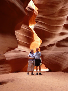
Our destination today is the Northern Rim of the Grand Canyon. Over half of the day we spent on the Hopi Reservation. Our key stop in route was Antelope Canyon. This is probably the most popular and photographed slot canyons in the world. Our guide is a nephew of the owner of this land, he had taken both geology and digital photography in college. Of course, he’s been giving tours of this canyon for years. So he knew just where to take the most interesting photos as well giving us the geology and history. Ahead of us was a group of 12, behind us another 12, and when we left a group of 30, yet we often had sections of the canyon all to ourselves. It is a dry stream bed most of the time, but floods sometimes after it rains. Depending upon the amount of rain, the sand is either swept completely out of this canyon or deposits itself there. The sand level was about 6 feet above the base rock when we went through. At times, the water will rise the entire 120 feet above the base. We felt very lucky because we ended up with just a group of four people touring this 400 foot canyon. It was just as wondrous as the photos I had seen of it with whirling bands of sandstone lit by the sun in places and completely dark in other. Some of the chambers were 20 feet wide, but the narrows were only 4-5 feet wide. Our guide knew the exact spot to take the most fascinating pictures, being sure to avoid getting any of the sky in the pictures, since that will ruin the color balance. Several shots have names like the corkscrew (yes, it look like one) and Monument valley (which looks like a dark butte in the bright colored sand. This was well worth the $31/person we paid for the tour.
John and Mary in Antelope Canyon

We headed on toward the Grand Canyon, getting over 6000 feet above sea level than plunging to the crossing of the Colorado river at Lee’s ferry at 3500 feet, and then back up to 6000 feet to get to our campsite. The Park’s campsite was full, so we’re staying at a forest campground just outside the park. We tried to take some sunset pictures of the canyon, but there wasn’t much of a sunset with too many clouds.

Thursday, September 30, 2010

Natural Bridges National Monument

Sipapu Bridge

We did a day trip from Monument valley today. First stop was Gooseneck State Park, where the San Juan river does about 4 turns right below the viewpoint, traveling several miles in what is probably no more than a 1000 feet in one direction. Then we took an interesting state highway, it went straight up a bluff in about 3 miles full of 5 MPH hairpin turns, all on a narrow gravel road.
The big stop was Natural Bridges National Monument where we viewed the 3 main bridges: Sipapu, Kachina, and Owachomo. I hiked down to the of Sipapu, an interesting 600 foot change in elevation in about .6 miles. Mary and I both went down to get a closer look at Owachomo. We learned that a bridge differs from an arch by how it was formed. Bridges have flowing water that carve them out, usually a river that pierces through the rock over time.
On the way back, we took the Valley of the Gods road, which has geology fairly similar to Monument Valley with lots of funny shaped buttes.

Horsecollar Ruins, occupied 1050-1300 AD

Wednesday, September 29, 2010

Monument Valley

View from John Ford Point


On the recommendations of others, we decided to do the full day tour of the valley with a guide rather than touring ourselves. It was well worth it! We spent most of the morning in Mystic Valley just south of Monument Valley. Here we explored a lot of arches: Skull arch, Half Moon arch, Honeymoon Arch. We also examined a number of Anasazi cliff dwellings. They were fairly small compared to what you would see in Mesa Verde, but were often accompanied by petroglyphs nearby depicting animals nearby. One called the House of many hands, had hand prints everywhere on the wall of the rock. Lunch was a huge burger with accompaniments in the shade of a big rock wall.
John and Mary at Honeymoon Arch

In the afternoon, we headed to Monument Valley. The first part was what anyone would see in their car: Left and Right Mitten, Merrick Butte, the 3 sisters, and probably the most spectacular view from John Ford's point. One immediately recognized the movie scene in one of John Wayne's movies. The campground where we are staying, relates to this scene. In the 1920's Hary and Leone Goulding bought land across from monument valley to start sheep herding. During the depression, everyone was suffering here. So they took their last $60 went to Hollywood with pictures of Monument Valley to convince them that this was the ideal spot for filming Westerns. John Ford saw the pictures and ended up making "Stage Coach"and other movies out here.
We left the main road and went through the back country. Part of our tour was watching a 90 year old woman, named Susie, preparing wool for a Navajo rug in her hogan, a traditional wood and mud building. We saw lots of rock formations and arches with interesting names like: Thunderbird rock, Sun's Eye, Ear of the Wind Arch, the sleeping dragon, totem pole, and the sleeping giant. Our final stop was the North Window to get a view of the familiar buttes of this area. Probably the best picture of the day, however, was taking at sunset from our campsite, which has this great view of the Valley.


Monument Valley from our campsite.

Tuesday, September 28, 2010

Four Corners

Fall colors outside Telluride

Today, the gorgeous Fall weather continued: blue sky, pleasant temperatures. We went over Dallas divide in the morning with the spikes of the San Juan mountains in the background and the golden leaves of Aspen in the foreground. We stopped in Telluride, which was ablaze with color in this deep valley. Then on through Lizard Head pass with oohs and aahs every time we took a turn. Wilson peak with a little snow on top and all the greens and gold below was the highlight of the day.

Wilson Peak

About noon, we came out of the mountains onto the sage brush plains. Our stop the Anasazi Museum outside Dolores, which gives a good history of the region. People have lived here since 11000 BC, but the most famous occupants were the Anasazi people from about 700 AD until they left in 1300 AD. They are most famous for the dwelling in Mesa Verde, but there are over 6000 ruins of their buildings in this region. Pueblos, Kivas, towers, and pit houses are all around this area. The best theory as to why they left is that the weather changed enough so that they no longer could grow corn here.
We continued on through four corners area - boy has this changed since our last visit. They are removing all the wood stalls and replacing them with brick, while the monument itself is now out of concrete. We continued our journey toward Monument Valley. This is dry, desert land, but the colors are really splendid.

Monday, September 27, 2010

To Ouray

Fall Colors on Monarch Pass


Today was mostly a travel day. We headed southwest from Denver on US 285. The aspen were displaying their colors on Kenosha pass where we stopped for lunch. But the highlight of the day was going over Monarch pass on US 50. The colors were a mix of green, yellow, and orange. Every time we took a corner a new view of aspen against the dark green of the conifer trees would arise. The river banks were also covered in yellow cottonwood trees.
We reached Ouray about 5 PM. Ouray is surrounded by mountains on 3 sides. It is often called the little Switzerland of Colorado because of the nature of these peaks. We had just enough light left to visit Box Canyon Falls. The falls drops about 200 feet here in a narrow, 20-foot wide canyon along the fault line. You can't see much of the falls, but you sure can hear it.
Dinner was at the Main Street Restaurant, a nice family place. Time to call it a day.

Monday, July 12, 2010

Cossack village

Typical Cossack house

This morning we visited a replica of a 17th-18th century Cossack village. Most surprising was the typical house with a bench on the outside for additional warmth in the winter, a drying space, and sitting; white walls with pancake glass and a straw roof. Inside it was decorated with embroidery. The stove served for both cooking, heating, and a warm bed. It was also decorated with the tree of life, a flower for every birth and a cross for each death. The wooden church has 3 domes for the trinity and a balcony for the priest to address those standing outside the church (since the inside can be quite small and stuffy). Finally, they had a rich home with Ukrainian baroque decorations. They had the usual craft areas, blacksmith and a potter, where Mary fashioned a small pot (with a little help).
We went for a good tasting lunch in a restaurant out of town. We were served our first and only chicken Kiev, stuffed with dill.
That evening, we had our farewell dinner with Ukrainian folk music and lots of vodka. Mary was the life of the party since several non-vodka drinkers offered her their glasses. We started with horseradish vodka and wine? What did we eat? Chicken, it was good.
Farewell folk music

So how do I summarize this trip? It was good to go with friends: Bill, Flo, Ruth, and Emily. We ate together the whole trip and shared our impressions. We also met people from across the US and lets not forget Thunder Bay, Canada.
We'll say we went to Russia and Kiev, but it was all in one timezone out of 11, sort of like going from New York City then cruising the Hudson river, Erie canal and Great Lakes to Cleveland and call that seeing the U.S. St. Petersburg was as memorable as our first visit 11 years ago with better roads, more stoplights, and probably 5x as many cars. Moscow, especially the Kremlin was a surprise, who expected 5 churches and only 2 government buildings? The cruise was like going through the North woods of Wisconsin visiting villages and towns along the way. Kiev, we weren't expecting anything and found a beautiful city.

The highlight of the trip, however, were the speakers: university students, Daniel from Ukraine, and especially the World War II veterans and the engineer from Chernobyl. All in all a great trip - I know a lot more about Russian history, people, and the capital cities.

Sunday, July 11, 2010

Cave Monastery, Ukranian history and life

Cathedral of the Assumption, Cave Monastery
The Cave Monastery was found in 1051 by Anthony about 3 km. outside Kiev. The original monastery was in a series of caves and later the buildings of the upper monastery were added beginning in the 12th century. Many come here on pilgrimage. The most imposing edifice is the Assumption of our Lady Cathedral. The original was blown up by the Nazis, so this is a reconstruction completed in 2000. Services were being held in the nearby Refectory Church (1895) where the monks prayed before their meals. The service is even stranger than a pre-Vatican II Catholic service. A lot of singing and chanting are done, while the Eucharist is conducted behind the iconstary. Most of the people both inside and outside the church seem to be in private prayer to various icons. They also write down the names of the living and dead who will be mentioned at the service. The caves themselves are used for services as well as a crypt burial space. 118 monks bodies underwent natural mummification and they are considered saints.
In the afternoon, our lecturer, Daniel, talked about Ukraine. All the Eastern Slav people were united as a country since the 7th century, called Kiev Rus. In 988, Vladimir the Great introduced Christianity to unite the country. In the 12th century, the mongols invaded all of Ukraine except the west. In the 15th century, the Poles conquered this western portion. They were defeated by the Cossacks in the 17th century. In 1654, the Cossacks signed a treat with the Russian Czar for protection against the Poles. This has resulted in western Ukraine being different than eastern and central Ukraine: Catholic vs. Orthodox, Ukrainian language vs. Russian, and a pro-European vs. pro-Russia orientation. In 1917, the Ukrainian people republic was proclaimed. In January, 1918 the western and central portions signed a unity treaty with the eastern portion. After 4 years of civil war, Ukraine became a republic in the USSR. In the late 20's, the Soviets started a de-nationalization campaign where they deported Ukrainians and imported other nationalities. In 1932-33, there was a manufactured famine, the crops were exported and over 10 million died. Stalin then proceeded to purge the intelligentsia in 1937-8 and over 2 million were killed or sent to Siberia. Today, 42% of the country is non-Ukrainian.

In 1991, Ukraine declared their independence. The political system seems to be stable with a 425 member Parliament, a president elected by the people (responsible for foreign affairs and with veto authority) and a judicial system. Daniel felt that the judicial system was confusing with multiple courts who can issue conflicting opinions.

What happened at the Orange Revolution? In 2004, four exit polls (other than the official one) predicted that the pro-European candidate had won, the opponent even conceded, then the official results were for the opponent. Over 10 million people protested wearing orange. The Supreme Court declared that a re-vote needed to occur, the protesters continued until the re- vote in 3 months. This was a historic change - the first protest against government, support for freedom of speech and the five TV stations actually stopped following the government line. An interesting fact, the next year the income tax paid by people doubled, people reported their previously hidden income. Ironically, the opposing candidate won at the next elections.
Independence Square, Kiev


The average salary here is about $300/mo. Four percent are considered rich, 12% middle class, and remaining near poverty level. Agriculture, natural gas, machinery and metallurgy are the primary industries. One of the problems is education, while 12 years of schooling is mandatory, there is a large gap between business needs and the university outputs, especially in science and business. Health care is free and quite good for most health problems. You call the hospital, describe your symptoms, and a doctor will make a house call. For serious surgery, there is a queue or you pay for a private hospital.

Overall, Daniel was hopeful for the future, "we have a lot of natural resources but industry must become more efficient. Most politicians are still former communists, but that will change with time. "

Saturday, July 10, 2010

Center of Kiev and the Chernobyl Museum


St. Sophia Cathdral, Kiev
Kiev is a city of 2.4 million, originally founded in the 5th century. On one side of the Dnieper, the city is hilly, this is the old city built here because it could be easily defended. Legend has it that the city was founded by 3 brothers: Kyi, Shchek, and Khoryv and their sister Lybid. By the 7th century, Kiev was the capital of Kiev Rus, a predecessor of today's Russia. In 988, the Christian religion, Byzantine style was chosen as the state religion. Many of the buildings here are named after buildings in Byzantium (Constantinople, Istanbul). For example our first stop was the Golden Gate, a 1980 replica of the gate into the old city. The original was damaged by the tartars in 1240. Here we were introduced to Yuraslav the Wise holding a miniature of St. Sophia cathedral. He was considered to be the one who built the cathedral, but recent study of some of the graffiti in the church indicates that it was started by his father, Vladimir in 1011. We entered the Cathedral through it 1701 bell tower. On the grounds is a stone telling of Yaraslav's library of over a thousand books. Only one survives today, a bible used for the marriage between a Ukrainian princess and the French King, Henry I.
St. Sophia was originally built with 13 domes in a style similar to St. Sophia's in Byzantium. In the 17th century, it was restored and changed to a Baroque style and six more pear shaped domes were added. Inside are some of the original 11th century frescoes and mosaics. Dominating the church is 22 foot tall mosaic of the Virgin Mary in blue and yellow (flag colors of Ukraine). On some of the pillars graffiti is carved from the early centuries and tell us when the church was built and the day of Yuroslav's death.
Two other churches of note were St. Andrews built by Elizabeth I as a royal chapel and St. Michael monastery. We also saw all the usual government buildings and square typical of a European capital.
Chernobyl after the accident

In the afternoon, we visited the Chernobyl museum. The radioactive discharge of reactor 4 of the Chernobyl nuclear plant occured in the early morning hours of April 26, 1986. The radiation equivalent of 1500 Hiroshima bombs was released into the atmosphere. The nearby town of 50,000 was told it was a small accident that morning and life continued as normal. After 36 hours, they were told to pack their belongings and buses arrived for a 'temporary' evacuation. On April 29th, the Swedes reported nuclear fallout and began investigating its source. The USSR admitted to an accident, which became 1 paragraph on page 3 of the Kiev newspaper. Kiev, only 75 miles away celebrated May Day with the usual parades. Finally, 74 villages and 2 towns, 90,000 people were evacuated. Today there still exists an exclusion zone 14 miles in radius surrounded by fencing where no one lives. But 600,000 people, mostly soldiers were involved in the cleanup, shoveling radioactive material by hand with little protection other than jumpsuits and respirators. Half of them are dead today - 25 years later.
The most interesting part of our visit was asking questions to one of the plant engineers. He had worked at the plant since its construction 12 years before. On the morning of the accident he was called at 5 AM and worked for the next 5 days to shut down the entire plant. Afterwards, the engineers joked about how long they had left to live - best guess, 1 year. He and his family (wife and 2 children 10 and 4) have had numerous treatments and surgeries. His daughter is not a doctor treating victims of the disaster. He is head of the victims support group.
Why did it happen? "The nuclear industry tries to hide the truth. There had been previous minor incidents with reactors of this type, but while there were investigations, the design flaws discovered were clouded in secrecy even to the people managing the other plants. In 1986, an international conference held in Vienna laid the blame on the operating personnel. Subsequently there have been 7 reports issued. It is clear that the operating personnel were following a manager's directions to conduct an experiment. A combination of this experiment, the design flaws, and the secrecy around these flaws probably led to the accident. It is interesting that within a month, the design flaws were recognized and all reactors of this type were modified. The design of the graphite rods used to control the reaction were modified to react faster.
Chernobyl reopened after a cap was put on the destroyed reactor. I continued to work there on the other 3 reactors. We go through two decontamination checkpoints in the exclusion area to work there. It was shutdown in 2000, primarily for political reasons."
Our next visit was to Babi Yar. In the time of Catherine the Great, many Jews immigrated to Russia because they needed more farmers and were granted land. In the 1890's 40% of Kiev and 80% of Odessa were Jewish. Then the pogroms began, causing many Russian Jews to emigrate to the U.S., Canada, and Palestine. On September 19th, 1941 the Germans took Kiev. On September 28th, they called for all Jews to report to the Jewish cemetery with all the goods they could carry, to be transported. That night, they shot 31,771 and dumped them in the "Women's Ravine", Babi Yar. The location of this ravine was only recently discovered because through the 2 years that Kiev was occupied, 200,000 were shot and buried in a site nearby. That is where a large monument was erected in 1971 to memorialize the citizens of the Soviet Union who were murdered here.

Babi Yar Memorial

Friday, July 9, 2010

Moscow to Kiev


The Bolshoi Theater


Our flight to Kiev isn't until 4:45 so we have the morning around Red Square. We found that the square was closed for some special delegation when we arrived. We skirted the square to take a look at the Bolshoi Theater, ran through the street vendors, and watched the changing of the guard at the tomb of the unknown soldier. We spent the majority of the time in the Russian State History Museum which covers from pre-history until 1917. The best part was seeing some of the museum rooms which were decorated similar to Russian churches and palaces. After lunch in Gums, we headed for the airport for our flight. We made it to the Radison only a few blocks from St. Sophia's about 7 PM.

Thursday, July 8, 2010

Great Patriotic War Veterans

Krushchev's grave

We started our day at the New Maiden Convent cemetery. The Russian Orthodox church didn't allow divorce, so the noblemen's wives would suddenly desire to be a nun, allowing their husbands to remarry. Several mothers of Czars ended up at this convent, so donations were plentiful. But after Peter the Great allowed divorce, donations went down, so the opened a graveyard for noblemen. Eventually this became the resting place for important communists: Gorbachev's wife, Boris Yeltsin, Andrei Tupolev, Nikita Krushchev, Andrei Gromyko, many World War II veterans, as well as singers, ballerinas, and movie stars.


Statue of Peter the Great

Our next stop was the statue of Peter the Great. Originally this was a statue of Columbus that Yeltsin was to give to Bush in 1992 (500th anniversary of Columbus discovering America). But the economy collapsed and Russia couldn't afford to ship the gift. Ever resourceful, in 1997 Columbus head was cut off and replaced with that of Peter the Great to celebrate the 300th anniversary of the Russian navy. So there is Peter with his back to the Kremlin on a 15th century ship.
Our last stop of the morning was the huge Church of Christ, the Savior originally built from 1837- 1883. In December, 1931, it was blown up by the Communists. Their plan was to build a skyscraper here taller than the Empire State Building. World War II intervened ending those plans. Krushchev later turned the foundation into a swimming pool. The church was rebuilt from 1995-2000 to the original design, though the materials used were cheaper. It still is quite impressive.

In the afternoon, 3 veterans of World War II, the Great Patriotic War talked to us. Remember 27M Russians died during the war, 13 M of them civilians. Our first veteran was a pilot who trained other pilots. "We were very inexperienced compared to the German pilots from 1941-43, it was at the Battle of Stalingrad that the tide turned. Much of this was due to the goods and planes supplied by America's lend-lease program."
Our second veteran , eventually became a general. As a 16 year old, he had one month of training before entering the battle. "The hardest time was the five minutes before the battle begins. When you see a large squadron of tanks approaching, you become fearful, but behind us was our Russian homeland. In 5 days of battle, I was one of 12 who survived from my unit of 1200. Even as a 12 year old, I went to school for half a day and worked the other half in a factory. Our motto was 'everything for the front line, everything for victory'. "


Veterans of the Great Patriotic War

Our final veteran was a woman nurse, one of 800,000 women who went to the front. "I was first stationed at Stalingrad and we were bombed with logs, rails, and nails falling from the sky. I was sixteen and started to cry, everything around me was on fire. I saw a wounded soldier on a nearby tank, but I was too short to reach him. A tall Siberian helped me reach him and I dragged him on his coat to the hospital. Later, our hospital was surrounded and I became a POW. As women, we carried buckets of sand to build a road, our hands would bleed from the weight. After 6 weeks, we were put on a train to Germany. Some men removed the floor boards from our car, we jumped under the speeding train to escape."

The general liberated a concentration camp near Berlin - only women remained, wearing wooden shoes with thing faced, many had been infected on purpose. All the men had been marched to the Baltic sea to be sunk on a barge. What impressed him most was the order of the Germans, the piles of shoes here, hair there, and suitcase in another pile. "Nearby we encountered German women and children torn from their homes by the war, we fed them with our supplies.

They went on, "In our day, everyone volunteered to defend the Motherland, regardless of politics. Today's generation is brought up by the media more than their parents. They see rich and poor people, this wasn't the case during Soviet times. Today they are fighting to get a good education because education brings riches. Most are envious of America".

Wednesday, July 7, 2010

Tretyakov Gallery

Portrait of young Tolstoy

Our primary visit today was the Tretyakov Gallery with a collection of a 1000 years of Russian art. We concentrated on the art from the 18th and 19th century. This museum started as a private collection in 1856. Tretyakov concentrated his collection on portraits of contemporary nobles and artisans as well as historic Russian works. Pavel Tretyakov became the biggest patron of the arts in his time. He paid to have portraits done of Tolstoy and Dostoevsky, and his tastes in art actually influenced the art of the time (he liked dark works with little sunshine). He actually built a museum next to his house for his collection and donated it to the city in 1892.
Russian art changed significantly during the time of Peter the Great. Previously Russian art was religious icons, where originality was discouraged. Peter saw the oil paintings of the Dutch masters and encouraged arts to learn these methods. Elizabeth I established the first art academy in 1757, later Russians learned from the Italians and French, starting a true school of Russian art in the mid-19th century.
In the evening we went to the new Moscow Circus. The communists created circus schools and circus building throughout the country. Most families take their children regularly to the circus. What we saw was a cross between traditional circus and Cirque du Soleil. Laser lights and both rock music and traditional circus music played by an orchestra. The acts were animal: dogs, cats, donkeys, alligators, lizards, and monkeys; human: trapeze, rope acrobatics, high bar gymnasts, and clowns; and it all finished with a walrus act in water. All on the one ring stage. It was thoroughly enjoyable.

Tuesday, July 6, 2010

The Kremlin

Cap of Monomakh
The fist Moscow Kremlin (fortress) was built in 1372. The current Kremlin is from the time of Ivan the Great, 1485 who unified Russia and freed them from the Mongols. The Kremlin has 1 1/2 miles of walls with 12 towers. We started our vist in the Armory. Here are the treasures of the Czars and noble families: liturgical vestments made of canvas, embroidered with gold thread and outlines in river pearls. Next were the imperial thrones made of simple wood underneath. Ivan the Terrible's throne in veneered in carved ivory and has been the coronation throne ever since. The throne of the early years of Peter the Great when he shared power with his brother Ivan is interesting since it has 2 seats in front and a screen with a seat behind it for the "power behind the throne", the regent Sophia. Numerous crowns were on display including the sable-trimmed Cap of Monomakh, as asian-style crown used since the 13th century for the Czar's coronation. The next room is filled with court carriages, five from the time of Elizabeth I plus the sled she used to get to Moscow from St. Petersburg to be crowned. Also interesting were some small carriages with mica windows used by Peter the Great as a child. Another room had an icon cover of gold with 2 large emeralds which the Spaniards took from the image of the Inca God. This icon cover was from Our Lady of Vladimyr in the Church of the Assumption. There were also a number of bible covers, the most impressive was for Catherine the Great, gold with over 1000 cators of diamonds, enamel portraits of the evangelists in the corners and in the center an enamal of Christ, whose face is the likeness of Catherine. We ended our tour with the Faberge Easter Eggs. Two were made each year for the royal family, each one contained a surprise. Ten of the 54 known eggs are here. For example one of the eggs celebrates the opening of the Transiberian Railway and inside was a miniature train.
Transiberian Railroad Egg

After leaving the Armory we had our biggest surprize of the day, Cathedral Square. Most impressive is Cathedral of the Assumption (Dormition), built by the Italian architect, Fiorvanti in 1475-79. This is the coronation church, covered with frescoes inside. Here we also ahve 3 pews: a small one for the Czar's wife, one for the Patriarch, and the Czar's with beautiful scenes carved in wood from the time of Ivan the Terrible. Around the square we also see the Cathedral of the Annunciation, the Palace of the Facets, the 11 domed Church of the palace, the Church of the Depositions of the Virgin's Robe, the Cathedral of the 12 Apostles, Ivan the Great belfry and bell tower, and the Cathedral of Michael, the Archangel, the burial spot of the early Czars.
The Churches of the Kremlin

Around the corner is the Czar bell, (200T) cast in the 1730s. As it was being carved and polished a fire broke out in the scaffolding and the bell cracked from the heat. Then comes the Czar cannon, the largest caliber in the world, but it has never been shot. We ended our tour with the office of the President of Russia. The Kremlin definately was not what I expected - more churches than government buildings.

In the evening we attended the Russia National Show in one of the large hotels. While there was lots of good dancing, it reminded me of Lord of the Dance with it pre-recorded music, which sometimes was Russian music with a beat.