Friday, October 15, 2010

Colorado National Monument

Independence Monument


This is our last real day of sightseeing. We’re off to Grand Junction to visit Colorado National Monument. We take Utah 128 through the Colorado Canyon always a scenic drive. After setting up camp, we head for the monument. After 3 weeks of sandstone, it is sort of anticlimactic, but surprise! We actually have new layers of sandstone, the Morrison layer filled with dinosaur bones and the Dakota formation. These are on top of our usual Entrata and Navajo sandstone. We took a nature trail, but there were no booklets left. Of course, at this point, we guess what the signs are pointing to – we know most of the desert plants and rock layers. We even know most of the animals including those that live in potholes.
There are some beautiful views: Independence monument and Ute Canyon with its fall colors are particularly beautiful.
Ute Canyon

So how do you sum up this vacation? While I’ve labeled it the Utah vacation or more accurate summary would be the Colorado plateau vacation: western Colorado, Northern Arizona, and Southern Utah. We’ve seen a lot of red sandstone everywhere, encountering the same layers over and over, but in different formations. The highlights were Monument Valley, Antelope Canyon, Zion Park (big horn sheep and the hummingbird talk), and our drive down Shaffer Trail in Canyon land. We were shocked at how many Europeans we saw everywhere, especially once you were hiking. I was expecting to see them in the major National Parks, but we met many every day. Most were young couples from Germany, Holland, and England who we ended up talking to as well as lots of other languages that we didn’t know.

Thursday, October 14, 2010

Arches National Park - Delicate Arch

Double Arch

We saw lots of arches today. We visited the Windows portion of the Park to hike to North and South Window as well as Turret Arch. Then it was a short walk to one of my favorite arches, Double Arch. This was a former pothole that eventually lost it’s center forming two adjacent arches. In the afternoon, I took the short, but strenuous hike to delicate arch. I couldn’t believe the number of people who were doing this hike. A good portion of the trail goes over slick rock, and even here you could tell where the trail was because of the darkened portion in the stone. The hike was well worth it, I couldn’t believe how incredible delicate arch is. It was much larger than I expected and so isolated from any other rock formations, you wonder how it came to form here. Simply incredible! We tried to take one of the 4 wheel drive roads out of the park, but it proved too much for us! It climbed straight up a hill with deep ruts and we decided not to chance getting stuck.

Delicate Arch

Wednesday, October 13, 2010

Arches National Park - Landscape Arch

Landscape Arch


Time for Arches National Park, last time we were here it was 104 degrees, today the high will be in the mid-70s. We had hoped to camp there, but I didn’t make a reservation in time and the campground we were in also was going to fill that day since it’s the start of a 4 day weekend for school. So we moved to the Moab KOA in the morning before heading to the park. I took a one-way hike down Park Avenue which has these huge towers rising above the wash. At the end of the wash was another huge rock called Courthouse Towers. Mary picked me up at the end and we continued down to Balanced Rock. There were at least 3 other balanced rocks in the vicinity so we wondered why they picked this one?
In the afternoon, we went to the Devil’s Garden area of the park and took the hike to Landscape Arch, taking short side trips to Tunnel Arch and Pine Tree Arch. This is the longest arch in the park, and its shape is so interesting. They no longer let you hike underneath the arch, since quite a bit of rock fell off several years ago.

Tuesday, October 12, 2010

Island in the Sky portion of Canyonlands

Green River from Deadhorse Point
Our day started at Dead Horse Point State Park, which overlooks the canyons of the Green and the Colorado rivers. The point got its name since it narrows to 30 feet at one point, which allows the cowboys to corral the horses on that point. The legend has it that after selecting the best horses, one group left the rest to die of thirst on this point.
Then we went on to the Island in the Sky portion of Canyonlands National Park. This part of the park is 2000 feet over the two rivers. We went from viewpoint to viewpoint and each would get better. We took a hike to upheaval overlook. This part of the park looks different (colors are grays and browns) in soft hills then the rest. There are two key theories to what happened here: either a salt dome collapsed or a meteor landed here spraying this material around. The other interesting hike was to Mesa Arch, which has a beautiful view of Buck Canyon (the Colorado river canyon) behind the arch.

Shaffer Trail (1500 feet down)


We ended the day with a 4 wheel drive adventure, we descended the island on the Shaffer trail. Mary almost had a heart attack as we went down this very steep, mostly one lane, shelf road with a drop off of 1500 feet on one side. We descended along a good portion of this at less than 5 mph and were lucky that the 3 cars we passed were along portions where we had already pulled off for the view. Even when we reached the end of the cliffs, it remained and interesting road going through many washes and cliff edges as we passed by dry streams that led to the Colorado. We had seen this road from many of the viewpoints in both parks, and now we were on it. Well, it took us 2 ½ hours of driving to finally reach paved roads, but it was definitely a worthwhile trip that few take. We had dinner at Moab Brewery, the food was good and they had both a good amber and stout beer.


Colorado River along our drive

Monday, October 11, 2010

Needles section of Canyonlands

Newspaper Rock
We’re off to the south end of Canyonlands National Park, called the needles. We stopped on the way to see Newspaper Rock, a series of petroglyphs and pictogryphs. There were about 6 of us there and we never felt that we found them. On returning later that afternoon, we found that we had hiked off on the wrong side of the parking lot. There were many pictures obvious on the right side. These pictures were created from 3 different cultures. Most of the human like shapes look like big men with antlers, and there are lots of big horn sheep.
Needles section as seen from Grand View Point
The needles section was fairly quick to explore by car. It’s obvious, why it is called needles as there are many spires that apparently go for miles (you can only see the first row of needles from the roads). There actually isn’t too much to see from the car, other than canyons (duh!) and rock formations. It was more interesting to hike on the pothole trail to get a closer look and the roadside ruin trail to get up close to an ancient granary.

Sunday, October 10, 2010

Goblin Valley State Park

Goblin Valley


We left Capital Reef and continued down Utah 24 which is another scenic byway. Our primary stop for the day was Goblin Valley State Park. It had been my intention to camp here, but we soon discovered you can explore the entire park in about 2 hours. The goblins or mushroom shaped stone figures are made of Entrada sandstone. Fracture patterns within the bed create zones of weakness, and the erosion begins. The edges and corners of these fractures weather more quickly producing spherical-shaped goblins.
The narrows of Little Wild Horse Canyon

Just down the road is another slot canyon, Little Wild Horse Canyon. The hike is primarily in a wash so it was fairly easy, until we came to a dry fall. Here we had to skirt the side of the wash and the climbing got a little too much for Mary. She decided to wait it out, while I explored the canyon. While not as spectacular as Antelope Canyon, this one gets very narrow. For several hundred feet, you hoped you didn’t meet anyone going the other way, because there was nowhere to pass. It was a fun canyon to hike. If you want to make it a round trip, you can also hike down Bell Canyon.
Given that it was only 2:30 PM, we decided to head into Moab for camping that night.

Saturday, October 9, 2010

Grand Staircase Escalante

Grand Staircase Escalante


Today, we’re headed down Utah 12, a scenic byway from Bryce Canyon to Capital Reef National Park. Our first stop was Kodachrome State Park. I was expecting much more colors than the mostly reds and whites we saw. The highlights of the park are the sandstone spires that dot the park. We took a short loop hike to see a little of the scenery. Some of the hike was in a wash, which were pretty muddy after all the rain this last week. Leaving the park, we headed down toward Grand Stair Case-Escalante National Monument. Highway 12 is one of only 2 roads that cover some of the corners of the monument. This part of Utah was the last part of the continental US to be explored, by John Wesley Powell in the early 1870s. The most spectacular part was the road from Escalante to Boulder, Utah. This section is called the million dollar highway, it was completed in the late 1930s. Boulder was the last town in the U.S. to get their mail by mule train – a 3 day trek from Escalante before this road was put in. The road north from Boulder to Torrey, Utah wasn’t paved until 1965. So this portion was only open 6 months a year. The scenery fit the remoteness of this area. Lots of impassable rock formations. It took most of the day for us to cover this 150 miles, but we made many stops on the numerous viewpoints.

Climb up Boulder Mountain to Torrey

Friday, October 8, 2010

Capital Reef

Mary at Hickman Bridge


We had hoped to take some of the dirt roads in the park today, but because of that recent rain, they are just mud. The rangers told us, that they should be dry in another 3 days and then they’ll try to push aside the mud. Oh, and the paved road just opened yesterday at 2:30 PM. So we visited the school house and one of the last settler’s cabins in Fruita. We just missed the last of the orchard fruit, apples were being picked as late as last week. We hiked to Hickman bridge a natural bridge up one of the canyons. Capital Reef is named after two features: the rock domes, one of which looks like the original U.S. capital dome, and the 100 miles worth of sandstone ridges, which are virtually impassable, just like reefs in the ocean. From our hike, we could see a lot of the domes as well as this beautiful bridge. Mary made it all the way, even though the trail was steep with steps in many spots. In the afternoon, we took the scenic drive, but with the major gorge roads closed, it was fairly disappointing. In the evening, we caught sunset from panorama point, it was spectacular. I attended the evening ranger program. It was mostly question and answers, but the rangers steered the conversation to interesting topics, like the Great Basin spadefoot toad. This toad spends most of its time deep in the sand waiting for a rain. There they become dehydrated, losing as much as 93% of their weight. When the rains come, they rehydrate, go on a eating binge for 2 days, mate and lay eggs. The eggs hatch into tadpoles in a few days, and their food is each other! The strongest survives and it reaches full maturity in 6 weeks, ready to bury itself in the sand and start the cycle again.

Sunset from Panorama Point

Thursday, October 7, 2010

Bryce Canyon in the sun

View from Bryce Point

We woke up in a fog this morning. I guess it’s a good day for doing laundry, which we have to do anyway. The fog lasted till about noon, followed by cloudy skies and then finally the sun came out about 3 PM. We went back into Bryce Canyon to take in all the viewpoints. With the mix of sun and clouds the colors really came out. We went back to Agua Canyon where yesterday the spires were in cloud and were able to see miles into the distance. The terrain around here certainly has a lot of cliffs and canyons. The mix of clouds and sun really made for interesting views. The top viewpoint for me was Bryce Point with almost a city of towers of red, browns, yellows, and white. At Sunset point I decided to take the Navajo loop trail into the canyon. What a different perspective to see all these hoodoos from below instead of above. And then the narrow canyon that I hiked down was deep in shadow from this now sunny day, making for really deep reds and browns. This was supposed to be a 1.2 mile loop, but it turned out to be a 1.6 mile back and forth. I bumped into some of the trail maintainers and they pointed out that a huge rock had fallen down on the trek back. The rock was 6 feet wide and 10 feet high, blocking the slot canyon on the way up. They have to bring in jack hammers and it will probably take 2 days to remove the rock. They pointed out that for this part of the trail has actually been closed most of the year, they finally opened it up only a few weeks ago, to be closed again by a rock that fell yesterday. It was really exciting to see the hoodoos from this different viewpoint.

Down the Navajo Trail

Wednesday, October 6, 2010

Bryce Canyon in the fog

Agua Point in the fog, Bryce Canyon


Today’s plan went out the window! We had planned to visit Cedar Breaks National Monument, tour the park and take a short scenic hike. As we left Cedar City on Utah 14, it was pouring rain. The highway climbed quite a ways up, the aspen were colorful, but soon the rain turned to snow. We continued to go up in the snowstorm and passed by 2 cars that had slid off the road. I was pretty nervous with the snow on the highway and a trailer being towed behind us. We saw the turnoff to Cedar Breaks, but it was at the very top of the pass in the snowstorm. This wasn’t the time to tour the park. We continued on and soon enough we came to where the snow plows had been out clearing the road and in a few miles more we were back to rain.
Anyway, we arrived without incident at Bryce Canyon National Park. We staying outside the Park in Ruby’s RV campground to recharge our batteries and make use of the laundry facilities. We went into the park in the rain and fog, but there wasn’t much to see. The highlight for the day was the ranger talk on natural and man-made disasters. I’m not sure what this has to do with Bryce Canyon but he had some interesting stories about the 1906 San Francisco earthquake and the Johnstown flood in Pennsylvania. The weather forecast is for thunderstorms tonight as well as a tornado watch. There has been 4” of rain here in the last 4 days, that’s about 3 times the normal amount for the month of October.

Tuesday, October 5, 2010

Rosenbrunch Wildlife Museum and Zion

Still raining, but at least we have an indoor activity planned. We visited the Rosenbrunch Wildlife Museum. This museum is stocked with stuffed animals that were hunted by the Rosenbrunch family on 5 continents and brought here. We were immediately reminded of our African Safari in Southern Africa as we saw many of the antelope variations we had seen in the wild. But the exhibit continues with North American mammals including bear mountain lion, Rocky Mountain sheep and goats and many types of deer and elk. Then comes Asia and many animals we have never seen. Most amazing was the saiga antelope which lives in Siberia and has a huge nasal cavity to warm the air. This animal is faster than a cheetah, clocked at 70 mph. The exhibit is well done with a narrative that explains most of the animals displayed here. They also put in quite a pitch for how hunters have managed to save many species either through their trophy taxes or by transporting some of the last of a species to protected private lands.
Saiga Antelope

We headed up to the Kolob canyon portion of Zion park, this has a 5 mile scenic drive with several hikes possible into the wild. The rain begins to pour one more time, but the land is very scenic. We stop for lunch in the pouring rain and finally give up on the weather. On the way down, however, a water fall has sprung up over the sandstone. We reach the bottom only to see the sky clear, so we head up one more time to see how the scenery has changed. The waterfall has disappeared, but the deep red colors really stand out now.

Kolub Canyon, Zion National Park

Monday, October 4, 2010

Zion Canyon

The Narrows


We wake to thunder this morning, the weather forecast gives an 80% chance of rain for both today and tomorrow. We decide to chance it and take the shuttle down Zion Canyon. Our first stop is Big Bend because a ranger has a telescope setup to look for California condors, but it begins to drizzle and we give up. We can see the Great White throne from here and Angel’s landing. We move up the canyon to the Narrows to take the riverside walk. Here the sandstone changes from Kayenta where the Virgin river can easily carve a wider to canyon to Navejo sandstone which is much harder making the canyon much narrower. The rain stops and the sun peaks out as we walk up the easy path to the point where you hike through the water. Given the thunderstorm possibility that doesn’t sound very inviting, who wants to have a flash flood greet you? As we return the rain start coming down, but we escape the worst of it under a rock overhang.
We continue on to weeping rock. Here we have a short steep walk where numerous plant species are along the path from cactus at the bottom to Oregon grape near the top. The water that weeps out from the hard shale has been measured to be 400 to 1200 years old since it fell as rain. I wonder how they measure the age of this rain, but forget to ask the ranger. By the time, we get down from the weeping rock, the rain has begun in earnest. So we head to the Zion Human History Museum for the displays, park movie, and a ranger talk on California condors. These huge birds with their wingspan of almost 9 feet, were almost extinct. In 1987, they captured the last 9 birds and began raising them in captivity. Beginning in 1992, they began to release the birds back to the wild. Today, there are over 180 birds, 2/3rds of them in California, and about a 1/3 nesting on the Vermillion cliffs in Arizona. The Arizona birds are often seen soaring over Zion Canyon in the summer and fall.
No campfire talk tonight, it rained almost steadily from 3 PM until the next morning.

View from our campsite

Sunday, October 3, 2010

Zion Park Big Horn and Hummingbirds

Desert Big Horn Sheep sunning themselves
We head from 45 degree temperatures on the North Rim of the Grand Canyon to the 80s in Zion National Park, passing the Vermillion cliffs marking the edge of the Colorado plateau once again. In Zion, we take the Zion-Carmel Highway, toward the eastern boundary of the park. This road is under construction, so we have to wait about 10 minutes before entering the 1 mile long tunnel. On the other side is the slick rock section of the park, which looks a lot like grey or red piles from either cows or more likely elephants. The most famous rock formation here is the Checkerboard mesa which is criss-crossed with cracks on its white face. Our most unusual site, however, is a herd of about 20 desert bighorn sheep sunning themselves on the rocks. There are 3 large rams, several younger males with spike horns as well as lots females. They nicely pose on the rocks while we and many others are taking photos. Unfortunately, one woman decides to get closer to the sheep and they decide to head down the valley to avoid her and begin feeding.

View on Canyon Overlook hike


Mary and I try to hike the ½ mile trail to the Canyon Overlook. It must be over 200 stairs, which Mary manages, but then just before the viewpoint, it becomes a trail along the side of a cliff and the railings disappear. I hike the final 200 yards to the viewpoint and its fabulous view of the Zion valley with red and white rock formations towering over it. The thunder and lightning start and we manage to head down in about ½ the time it took to climb.
We had a hot Mexican meal in town at CafĂ© Oscar on the outdoor patio, followed that evening by a great ranger talk on hummingbirds. Did you know that hummingbirds have to eat 10 calories a day, that’s equivalent to us eating 125,000 a day? She has great pictures of several species of hummingbirds. Most interesting were some of their nests made of plant fiber (like the cotton from cottonwood trees or cattails) and held together with 1200 feet of spider web. The nests are camouflaged to fit the environment around them. The female lays 2 eggs about 1/3 the size of a dime, but this is equivalent to a woman having a 25 pound baby. She then feeds the two young birds with a mixture of nectar and insect parts for several weeks. The spider web allows the nest to expand as the fledglings grow bigger until they finally fly off.

Saturday, October 2, 2010

North Rim Grand Canyon

Colorado River Gorge from Imperial Point

We toured the North Rim of the canyon today. The aspen are all aglow in yellows and oranges. Since there was a fire in 2000, many of the Ponderosa pine are just stumps and the aspen are taking over for a few years. We headed out to Imperial point the highest point in the park. There we got a good shot of the country we had traveled yesterday with the Colorado winding its way to the canyon. We continued on toward Cape Royal stopping at the various vistas. I keep hoping to catch a shot of aspen with the canyon, but the angles are never right. At Cape Royal, you get the only view of the Colorado river you can see from this rim. It’s almost 10 miles away and 3500 feet below us. We get a peak of it through Angel’s Window and then a better view of the rich valley bend here, where people have inhabited this area for centuries. At Walhala overlook we bump into a ranger talk about the people who lived here. Apparently, they are starting to use the term “ancient pueblo people’ rather than Anasazi, because it is an Apache term and has a meaning similar to ‘ancient enemies’. Yet the Hopi and other pueblo people are clearly the descendents of these people. They primarily stayed in the canyon, but also farmed the rims here when the population was too large. There are some ruins of their pueblos just across from the overlook.
Grand Canyon from Roosevelt Point

We returned to the lodge for a geology talk. The ranger was very expressive, demonstrating how Arizona has risen and then dropped to be a sea level at least 3 times. The Grand Canyon starting forming after the Rockies were lifted. Why here? 1) There is a lot of carving action because the Colorado drops from 3000 feet. 2) It is an arid climate, so you can see the canyon walls, rather than a lot of greenery. 3) The San Andreus fault broke an opening to the sea for the river to flow toward. 4) The layers of former sediment are a large high plain here, that is they are flat, allowing us to see all the layers down to the base rock. I ended the day hiking out to Bright Angel Point because the sun was behind the clouds the colors were quite vivid.

Friday, October 1, 2010

Antelope Canyon

The Corkscrew, Antelope Canyon
Our destination today is the Northern Rim of the Grand Canyon. Over half of the day we spent on the Hopi Reservation. Our key stop in route was Antelope Canyon. This is probably the most popular and photographed slot canyons in the world. Our guide is a nephew of the owner of this land, he had taken both geology and digital photography in college. Of course, he’s been giving tours of this canyon for years. So he knew just where to take the most interesting photos as well giving us the geology and history. Ahead of us was a group of 12, behind us another 12, and when we left a group of 30, yet we often had sections of the canyon all to ourselves. It is a dry stream bed most of the time, but floods sometimes after it rains. Depending upon the amount of rain, the sand is either swept completely out of this canyon or deposits itself there. The sand level was about 6 feet above the base rock when we went through. At times, the water will rise the entire 120 feet above the base. We felt very lucky because we ended up with just a group of four people touring this 400 foot canyon. It was just as wondrous as the photos I had seen of it with whirling bands of sandstone lit by the sun in places and completely dark in other. Some of the chambers were 20 feet wide, but the narrows were only 4-5 feet wide. Our guide knew the exact spot to take the most fascinating pictures, being sure to avoid getting any of the sky in the pictures, since that will ruin the color balance. Several shots have names like the corkscrew (yes, it look like one) and Monument valley (which looks like a dark butte in the bright colored sand. This was well worth the $31/person we paid for the tour.
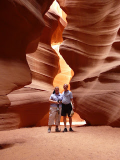
John and Mary in Antelope Canyon

We headed on toward the Grand Canyon, getting over 6000 feet above sea level than plunging to the crossing of the Colorado river at Lee’s ferry at 3500 feet, and then back up to 6000 feet to get to our campsite. The Park’s campsite was full, so we’re staying at a forest campground just outside the park. We tried to take some sunset pictures of the canyon, but there wasn’t much of a sunset with too many clouds.