Sunday, October 2, 2016

San Juan Mountains

San Juan colors

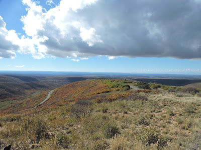
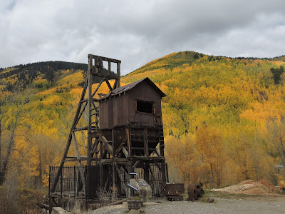
We had seen the Aspen colors from the tops of the mesa in Mesa Verde. Today we traveled the San Juan Mountain scenic byway and got to see them close up. Our timing was pretty good – most of the Aspen were at peak colors. It was totally awesome! Our only wish was a little more sun – it was a fairly cloudy day, so that dulled the colors out. We stopped for the evening in Chalk Creek Campground near Buena Vista. We found a great dinner place in Buena Vista: Jan’s Restaurant, family dining with mostly handmade fare.


How to summarize the trip? As usual, the Utah parks were great, but crowded – always amazed at the variety of rocks and sandstone. We saw quite a few National Monuments around Indian dwellings: pit houses to pueblos, which had quite a variety of architectures depending upon when and where they were built. We gained a much better appreciation of desert plants and animals at the Desert Botanical Gardens, and Arizona – Sonora Desert Park (a key highlight of the trip). Almost sad to go home, but the weather will be changing pretty quickly and we lucked out for the most part with weather on this trip. If you'd like to see more pictures and video, there is a 15 minutes video available on youtube at https://youtu.be/bH0SFJNxAIQ 

Saturday, October 1, 2016

Mesa Verde in fall colors

We spent most of yesterday traveling to Mesa Verde, arriving about 3 PM. Today, we visited Wetherill Mesa. First, we went to Step House, so named because of the steps that lead down from the cliff to the house. This is an interesting location because there are actually two archaeological sites here. The first consists of several pit houses which were occupied by basket weavers from approximately 600 AD. The second is a masonry pueblo building from 1200 AD.

Step House Pit House with restored roof

In the afternoon, I joined a ranger guided hike to Long House. The ranger was quite entertaining. We had an older newlywed couple on the tour, and he asked them to plan their reception. What would they serve for hor d’ouevres, drinks, and a main course. The woman was quite good:                 hor d’ouevres was rabbit with prickly pear juice; the main course was deer with yucca fruit and corn as a side dish.  The village here is almost 300 feet long and includes about 150 rooms and 21 kivas. This appears to be a ceremonial site since it has a large central plaza with seats – a great kiva. Many of the original walls are still intact with the beams that support them. In the back of the cliff is a seeping spring, with collecting holes to dip for the water.

Long House

We then went to the Chapin museum for the park movie (which actually did a great job of talking about the ancient Indian tribes in most of the southwest) and their collection of artifacts. The displays were from the 1930’s, but had a good cross-section of artifacts – pots, tools, clothes, food, baskets, etc.

That night Mesa Verde had a star party! They invited in an amateur astronomer, who has given star parties at other nearby National Parks. They set up about six telescopes and everyone, got a chance to see Saturn (with their rings perpendicular to earth). Then he pointed out the various constellations in the sky and told an Ancient Pueblo, Navajo, and Roman legend relating to the constellations. While we were watching the sky, both the International Space Station and an Iridium satellite passed by. The satellite flashed brightly for a couple seconds when the solar panels reflected the sun to us. They finished up by pointing each of the telescopes to a different object in the sky: the Andromeda Galaxy, and several star clusters. It was a fun night. 

Thursday, September 29, 2016

Petrified Forest National Park

Salt River Canyon

Most of our day was spent heading north from Tucson on Highway 77. The highway is one of those very scenic highways with the countryside constantly changing from desert to canyons. We ended up going up and down quite a few times. The most spectacular was descending into the Salt River Canyon. We felt like we were heading down into the Grand Canyon, just not quite as deep. We stopped here for lunch because of the scenic views.

Rainbow Forest at Petrified Forest NP

We arrived in Hobrook, AZ about 3 PM and headed immediately to Petrified Forest National Park. At the Rainbow Forest Visitor Center we took the Giant Log Trail. Here there are petrified logs strewn about the valley. It had just finished raining so the rainbow colors really stood out as we walked this half mile trail. Further up the road, I hiked the Crystal Forest Trail – again the colors stood out. Some of the petrified wood, looked just like natural trees lying on the ground, until you approached closely on could see it was rock. We also stopped at the Agate Bridge, the pictures showed people crossing this petrified log in the 1880s. Today it is fortified by concrete (from 1917) and has broken into several pieces. Newspaper Rock along the road had a series of interesting petroglyphs, but it was hard to see without the telescope provided. We continued on the scenic road to viewpoints of the Painted Desert. Since it was approaching sunset, the reds of the desert really stood out. We left just before the gates closed at 6 PM. 

Painted Desert at sunset


Wednesday, September 28, 2016

Saguaro National Park

Saguaro National Park

Saguaro National Park is divided into two parts on either side of Tucson. We started on the West side taking a road that dips up and down while traversing the Sonora Desert. The visitor center had an interesting film on the area. According to the film, the Native Americans believe that Saguaro are their ancestors and thus need to be well treated. The film ends with the screen lifting and there is the desert before you. We also took the loop road through the park, but didn’t have time for any of the hikes. 

Sleeping Mountain Lion

The highlight of the day was the Arizona - Sonora Desert Museum in the Tucson Mountain Park. Museum doesn’t seem quite the right term – most of the museum was outdoors, a mixture of a botanical garden and zoo with some geology mixed in. Everything we saw was part of the desert: lizards and snakes, tarantulas, the cats of the desert, coyotes, javelins, desert sheep, birds, bats, and frogs and toads. Of course, there were lots of cacti, trees, and bushes (a repeat of the Desert botanical park), and then a section on the geology of Arizona – the geological history, and the story of caves in the area. We easily spent 2 hours and could have spent more time – we skipped the section on hummingbirds, butterflies, and bees. 

Desert Garden

Then we headed to Mission Xavier del Bac, established by the Spanish in this area in 1692 and still serving the Native American Community. Finally, we took the loop road on the East side of the National Park. We did this quickly because it began to rain. Quite an interesting and packed day. We didn’t have time to do the Sky Island Scenic drive because it was beginning to get dark. I clearly tried to pack too much into one day. 

Mission Xavier del Bac


Tuesday, September 27, 2016

Arizona State University


We headed for Tucson, a new destination for us. We stayed at the Prince of Tucson RV Park, a very clean park with a pool, and a big wall above us preventing the highway noise from reaching our trailer. Mary wasn’t feeling too well, so she stayed at the trailer while I visited two of the museums at Arizona State University. The first was the Center for Creative Photography. I was hoping to see some great landscape pictures, but there were 3 galleries of various pictures – mostly black and white of varying topics. They also had a lot of books of photos – most of them strange: faces of ranchers, rest stops of the southwest, “sleepless nights watching Law and Order”, Camping for Japanese (about the Japanese internment camps in World War II). I was disappointed.

Ceramic from 1050 AD

Then I went to the Arizona State Museum. They are known for their huge Indian Pottery exhibit, which had pottery from the 900’s till modern day. They also had a section on each of the primary Indian tribes of Arizona, and Northern Mexico. It was well done. For each tribe, they explained about the tribe, their creation story, their primary celebrations, and their history. What was surprising was how the whites have treated the Indians, not only in early times, but as late as the 1980s. For example, it wasn’t until 1992 that the Bureau of Land Management stopped planning a dam site that would have put 2/3rd of one Indian reservation under water. 

Artifacts from Colorado River People


Monday, September 26, 2016

Phoenix

Desert Botanical Gardens

It cooled down for today, high only about 89 degrees. We went to the Desert Botanical Garden. I’m used to a small section in a botanical garden that displays cacti and other desert plants, here the entire garden was dedicated to the desert plants. The variety of cacti was amazing. Of course, the secret of a cactus is that it stores water inside the plant when it rains. They have a rib structure that can expand after a rain, and most of them looked pregnant with rain. There were lots of strange cactus: purple prickly pear, octopus, saguaro cactus that seemed to have faces. A major part of the garden was a tour of the Sonoran desert (which is where Phoenix is located), besides the plants, there were displays about how the people lived there.

Purple Prickly Pear

In the afternoon, we visited the Hall of Flame Fire Museum. This is the largest collection of fire fighting equipment in the U.S. The collection started with a hand pump from 1725 and ended with engines from the 1960’s, which served until the 90s. The most fascinating part was some of the decorated fire pumps and carriages that were used in parades and competitions between fire companies. The museum did a good job of explaining the changes in technology over time: some of the early chemical pumps to put out smaller fires without water, how the water pumps became more powerful from hand pumps to steam pumps to diesels, as well as the tech to raise ladders to higher buildings. We also learned about the technology of fire boxes which used to be distributed through the city, and when pulled they sent a signal to the central fire control, which then signaled the appropriate fire station about the fire. We finished up with a video and display about fire jumpers.

Decorative Fire Carriage


That night back in our trailer, we were watching TV, when we heard a police helicopter circling in the sky above us and pointing its spotlight about two blocks away. This lasted for over half an hour. We were never sure what actually happened, but soon after police cars were going through the RV Park with their lights looking for something or someone. In the morning, we learned that our neighbors had called the cops to check on things, because they found some papers and other junk near their trailer, and were worried that someone had come through the area. Who knows? 

Sunday, September 25, 2016

Heard Museum

Mosaic at Heard Museum

We had a second cold night in Flagstaff, low in the 30’s. Flagstaff is at 7000’ and we’re headed to Phoenix at about 2000, so the temperature rose from the low 50s to the mid-90s during our trip. Our primary tourist activity today is the Heard Museum, which specializes in Southwest Indian culture and art. We took one of the guided tours of the highlights of the museum. Our guide emphasized the modern art pieces and told stories about the artist or the pieces themselves. He seemed to assume we would know the artists. He finished with an exhibit about the Indian Boarding Schools. Here we learned how the Indian Affairs Department, beginning in about 1880, took the children off reservation, dressed them as Americans and taught them to become Christian Americans. They were torn away from their family, their culture, and their language for years. While they did learn a trade, they were neither welcomed as Americans or Indians anymore. This started changing in the 1930’s, when they were allowed to speak their language and participate in the various Indian cultural practices (since they all came from different tribes, they began to learn about the cultures of other Native Americans). On our own, we also came upon what we had expected in the museum, pottery, clothes, and art of the various Indian tribes of the area.
Indian Boarding School

Saturday, September 24, 2016

Around Sedona

Walnut Canyon Dwelling

We started our day just outside of Flagstaff visiting Walnut Canyon National Monument. Here were a series of cliff dwellings which used the natural recesses in the limestone of the canyon as their roofs built between 1125 and 1250 AD. The island trail was quite fascinating because you are on an island of rock rising from the canyon. The contrast between the two sides of the island was amazing, in the shade - a pine tree forest and in the sun - a desert landscape. They also built one-room pit houses near their fields. In addition to the island trail, there was an easy trail along the rim that gives you good views of the cliff dwellings.

Oak Creek Canyon

Then we headed on to Oak Creek Canyon and the Sedona area. The highway dives into the canyon and the rock formations loomed above us. We missed the scenic view at the start of the canyon and there were only a few places to pull off to really see the canyon, particularly since trees block the view in many places. Fortunately, we found a picnic spot and caught some of the views from there. We tried to stop at another scenic spot as we came out of the canyon. The gate guard there suggested that we go up to a view spot near the airport (which is built on a mesa above Sedona). It was a great view of the town of Sedona and the picturesque peaks. Sedona itself was a smaller version of Sante Fe – lots of places to eat and art galleries. We didn’t stop, since this isn’t our thing.


We continued on to Tuzigoot National Monument – another Indian settlement from about 1200 AD. This was different from our two previous Indian settlement, the 100 room settlement was made from rough stones and towered above the Verde River valley. At least this place, made sense for a farming community, there was a big river and lots of relatively flat ground for cultivation. Here we learned that the Sanagua culture came from Spanish meaning “without water” how appropriate for most of the region we toured. 

Tuzigoot Dwelling


Friday, September 23, 2016

Wupatki and Sunset Crater

Wupatki Pueblo

We woke up to 33 degrees, but the sun was out. We headed down to Flagstaff. We parked our trailer at J&H RV Park (a really well kept up site with gravel filled pull-through sites), but its Wi-fi was poor. Then we headed to Wupatki National Monument which holds a number of well-preserved ruins from the 12th century. We stopped at a number of box canyon dwellings and the Lomaki Pueblo, but the highlight was the Wupatki Pueblo. This community had over 100 rooms, many of them there for ceremonial purposes. This community was at the crossroads of several cultural traditions and has a mix of these cultures in its pottery and buildings. The complex includes a ball field, which the NPS has restored, one of 200 such fields in Arizona, but I don’t think we’ve ever seen one before. 

Idea of what it looked like

Then we went on to Sunset Crater, which last erupted between 1040 and 1100. There is evidence of villages that had to be abandoned when it blew. The ash layer may actually have led to the foundation of the Wupatki pueblo because the ash absorbed water, preventing evaporation and helping agriculture. As we hiked at the base of the crater, you could see the remnants of the lava flows and cinder cones, but the volcano itself is primarily made of cinder rock, where very little water is retained. Sunset crater was the last of the eruptions of multiple volcanoes centered on the San Francisco Mountains. As we looked around you could see lots of cinder cones around the area. 

Sunset Crater and Lava Fields


Thursday, September 22, 2016

Grand Canyon

Grand Canyon in the fog

We woke up to rain, first just some sprinklers and then a full blown shower. What better stop than the Visitor Center where we saw an excellent park movie with some of the history of the area and an 8 minute video explaining the geology of the canyon and how it was formed. The rain stopped for a moment and I got a photo from Mather point of the canyon – all in a cloud.

Sun comes out

Mary decided to head back to the trailer where we ate lunch. I decided to chance the weather and went to Yavapai Point and Geology Museum. While I was in the museum, the rain stopped, so I headed down the Trail of Time along the rim. Here each step amounted to a million years of Geological Time and they displayed the Canyon rocks from that era. There were still clouds in the canyon, but the sun started peeping out making for some great scenery. There were only a few people on the trail as I continued on the Verkamp’s Visitor Center, which explained the human history of this area, especially the early entrepreneurs who started tourism here. This was followed by Lookout Studio, another unique building made of stone, then Kolb Studio. 

View from Lookout Studio (notice the rain pool)

The sun and clouds continued to play in the canyon as I walked the rim. Passing Bright Angel Trailhead you could see the Indian Gardens down several thousand feet in the Canyon, where the Indians lived and tended their crops. I continued on to Maricopa Point. From there I took the shuttle another six miles out to Pima Point to get view of the western canyon. From here, you could see the Colorado River flowing through the Canyon. The sun continued to shine and it became quite a normal sunny day. Tonight, it is supposed to get down to 40 degrees, so I hope our furnace will work well. 

Pima Point West


Wednesday, September 21, 2016

To the Grand Canyon

Looking North from Desert View

Today was primarily a travel day. We headed toward the North Rim of the Grand Canyon (but didn’t stop there) and then along the Vermillion Cliffs, over Marble Canyon on the bridge that crosses the Colorado River and finally into the East Entrance of Grand Canyon. We stopped at Desert View Watch Tower to get our first glance of the Canyon. From here, you can see the Colorado come into the Canyon. Unfortunately, due to a forest fire, there is a lot of haze over the Canyon and so it wasn’t as crisp as we’ve seen it in the past. The tower itself is an interesting piece of architecture, it’s a modern structure, but gets a lot of its inspiration from Indian dwellings of the Southwest. 

Desert View Tower

We also paid a quick visit to the Tusayan Ruins and Museum. The ruins weren’t as good as what we saw at Anasazi State Park, but the small museum was quite interesting. We stopped at a few other viewpoints before reaching our campsite at the Kaibab/Ten X campground about 4 miles south of the park. (Once again, the park campgrounds were full.) But this is a spacious campground with lots of paved pull-through sites for trailers. 

Tuesday, September 20, 2016

Zion National Park

The Narrows

We took the town shuttle to the park, walked into the park, and then took the park shuttle along the Zion Scenic Drive. It became quite clear, why they don’t allow cars to drive this road, there are few parking places, and many visitors. A shuttle leaves every six minutes from each of the stops until well after dark. We stopped at Weeping Rock, where the water seeps out of the rock, providing a mini-climate which is good for ferns and Columbine. You can hear the waterfalls as you approach this pretty grotto. Then we took the River Walk along the Virgin River. Again, we observed significant mini-climates as you walk along: desert, Cottonwood groves, swamps, and hanging gardens. The trail ends at the narrows, where you can continue on, if you like, in the river. That would be a little too much for Mary.

Angel's Landing

We had a picnic in the Grotto and while Mary headed back to the trailer, I had to try the trail to Angel’s Landing. Angel’s landing is a big rock face at the top of the Canyon providing a spectacular view of the entire canyon. I couldn’t believe the number of people on this trail. The first two miles of the trail is almost entirely paved because of the crowds. It also has to be one of the most strenuous 2 miles I’ve ever seen, since you climb from the bottom of the canyon to the top.

The first climb


The final part of the climb is called the wiggles – 10-12 hairpin curves in the trail, they had to blast the rock face to make this trail. At the top is Scout’s Outlook with a great view toward the narrows. From here the trail is rock climbing with chains bolted into the rock to assist you. It’s a one way path, so for each section you have to wait for a group to get passed you. I did about a quarter mile and came upon a great view toward the entrance of the Canyon. The next section of the trail was narrower with 1000 foot drop-offs on either side. There were so many people on the trail, I decided I just didn’t feel up to it, given the crazy things people had already done just to get to here (forging their own paths to get by folks when a miss-step could cause you to fall). Enough for one day, I was pretty tired by the time I got back to the shuttle. We had a good Mexican dinner that night at Casa de Amigos, huge portions with different spices than we are used to and great chips and salsa. 

View from the top

Monday, September 19, 2016

Cedar Breaks National Monument

Fall Colors near Cedar Breaks

Leaving Bryce, we wanted to finally see Cedar Breaks National Monument (last time we were stopped by 4 inches of snow). Cedar Breaks is at 10,000 feet of altitude, so as we approached from the North, we went through quite a few Aspen glens. We observed brilliant yellows, oranges, and even some red leaves. When we turned into the park, the forest changed to Engelmann Spruce. But here most of the trees were dead, victims of the Spruce Beetle, which attacked this area in the early 1990s. We did a little hike to Alpine Lake. The lake itself was scenic, but I was disappointed that we didn’t have any major viewpoints along the trail. 

Alpine Lake

As we returned to the highway, we did have those viewpoints, and found that Cedar Breaks was a mini-Bryce Canyon, but the cliffs faced to the West, rather than the East and there were fewer people. 

Cedar Breaks Amphitheater

We continued on to the Kolob Canyon portion of Zion National Park. The 5 mile scenic road gives you several viewpoints of the canyon. At the end of the road, I took the short Timber Creek Trail which provides a viewpoint of the valley below the canyon. We continued on to Springdale, the town just outside Zion National Park. Since I couldn’t get reservations in the park, we stayed at the Quality Inn RV Campground. This campground is full service and just outside the park. You need reservations somewhere or you’ll won’t camp anywhere near Zion. 

Kolob Canyon

Sunday, September 18, 2016

Bryce Canyon


Yovimpa Point, Bryce Canyon

We took picturesque Utah 12 to Bryce Canyon. The highway goes through Escalante Staircase National Monument. The highway climbs along a ridge and there are deep canyons on either side of your vehicle. The road continues to go up and down through various rock formations, simply spectacular. As we approached Bryce Canyon, we could see the bright red hoodoo formations in the distance before we entered the park. We arrived before noon and found a nice campsite in the park. In the afternoon, we took the scenic road. One goes to the end of the road and then returns stopping at each of the viewpoints. Close-up are the hoodoos of the Canyon and in the distance are the mountains of Escalante.

Along Queens Garden Trail

After our car tour, I decided to try the Queen’s Garden – Navaho Loop trail. The trail descends about 320 feet from the rim of the canyon, so soon the hoodoo formations are rising above you. The Queen’s garden is so named because one of those formations looks like a statue of Queen Victoria. The connecting path to the Navaho Trail is fairly flat in a pine forest. When you get to the Navaho trail, you can choose one of two directions to get back to the top. I chose the Wall Street route because last time we were here it was closed due to a recent rain storm. It was quickly evident why this would close, it is very steep with the walls of the canyon rising above you on both sides. Rain causes the trail to become a muddy stream carrying away what comes off the walls. After dinner we returned to Sunset Point to observe the sunset, but there wasn’t many clouds so it was disappointing. We then went to the ranger talk on the geology of the area. It was a good talk – we learned how the colors and composition of the rock tell you whether that was created in deep ocean, shallow shore, beach, river, or sand dunes. All produce different types of sandstone. 

Wall Street


Saturday, September 17, 2016

Waterfold Pocket

Capital Reef

Last time we were here, it had just rained and most of the dirt roads were closed. So today, we decided to take Notum-Bullfrog road to the Burr Trail Road to get a good look at the Waterpocket Fold. Capital Reef is a compound name, Capitol from the white stone formation that looks the U.S. Capitol and Reef from the fact that the stone ridges reminded folks of a barrier reef in the ocean, making it difficult to get across this barrier. We could really appreciate this barrier as we traveled south along the Eastern boundary of the Reef. Then we turned West on the Burr Trail road, an old cattle trail. The exciting part was the series of 5 or 6 switchbacks to climb the reef. The views were fantastic. At the top things flattened out then we started the descent. 

Climbing Burr Trail

After we left the park, we followed Long Canyon for about 20 miles with the red cliff faces above us. We finally made it to Boulder, where we visited the Anasazi State Museum. Here an Anasazi village from about 1200 AD had been excavated and the museum explained what we knew about that culture as well as displaying quite a few artifacts. Outside some of the original diggings are there as well as a recreation of what their lodging and storage would look like. Then we headed north on Utah 12 over Boulder Mountain. This has to be one of the most scenic highways we’ve ever been on. In the high country the Aspen were turning bright gold, while below we could see all the sandstone layers of Capitol Reef. As one woman told me: everywhere you turn, it’s another beautiful viewpoint!

Long Canyon

Friday, September 16, 2016

Capitol Reef National Park

Capitol Gorge

The drive to Capitol Reef becomes quite scenic after we reached Hanksville. The rock formations around are just spectacular and that is what Capitol Reef is all about. We reached the campground at about noon and it was already full. This is a lovely campground in the middle of an orchard. This is the first time we’ve found it full, apparently the park is getting a lot more visitors and that is evident by the difficulty even finding a parking place at the visitor center or any of the trailheads. We went on to Torrey and felt fortunate to find a camping spot at a Sand Creek Campground (which only has about 20 campsites). The campground is quiet and the people have all been quite friendly.

The walls of Capitol Gorge

We took the Scenic Road in Capitol Reef Park and then the Capitol Gorge road. We got behind some drivers who were pretty fearful of this road, even though it didn’t even require high clearance. We took the easy trail at the end of the road for about a mile. You definitely feel small as you traverse the trail. We passed some petroglyphs as we walked through this deep canyon. At the end, I climbed out to reach three pools that were filled with water called the Tanks. Tadpoles were living in the largest pool. The temperature was only in the mid-70’s while we walked, but with the sun reflecting off the canyon walls it felt like 90 degrees.

Petroglyphs


Thursday, September 15, 2016

Arches National Park

Devil's Garden

We were shocked by the huge line to get in the park at about 10 AM. We headed directly to the Devil’s Garden area of the park (the end of the road). Thank goodness we lost cars along the way. We got one of the few remaining parking spots for the trail. Mary and I walked to Landscape Arch, a nice easy 1.6 mile trail. Mary returned to the car, and I continued on. 

Landscape Arch

The trail started scaling the rocks just a few hundred feet from Landscape Arch. Partition Arch was particularly interesting, since we looked through the Arch down to the trail far below. On the way to Navajo Arch, there were some interesting rock formations in the rock wall – holes and indents, sort of miniature arches. On the way, to Double O Arch I was following a group of people, and we all lost the trail. I could see it below, so I scrambled down the rocks to the trail. That cause me to miss the trail to Double O arch, but I continued on the primitive trail taking a different way back to the parking lot. On the way, I (and a few others) took a spur trail to Private Arch. Then further onto the primitive trail, where I took wrong turns at least twice and had to retrace my track to find the rock cairns of the true trail. I was amazed at the number of people who took the primitive trail, since we were scrambling up and down rocks, following a wash, or trekking in deep sand most of the way. It was fun, but I was tired by the time I returned to the parking lot. 


Rock wall with water seepage holes

We stopped for a picnic and then a quick hike to Sand Dune Arch and Broken Arch. Rather than take the main road back to town, we decided to try Willow Flats road which required high profile vehicles. Well, that was an interesting road. We went bouncing along, sometimes hitting rocks with our trailer hitch as we went up and down. Mary was driving and did a great job – but at one point we almost got stuck between a sand pit and a rock face. She put it into 4 wheel drive and with only 3 wheels on the ground (first a front wheel in the air, and then a back wheel) managed to get out of the sand pit. The road was a very long 8 miles to the highway. For dinner, we had a good pub dinner and beers at the Moab Brewery.